@discoverhalifaxva
The stars shine brighter in Halifax County, VA

SoVa Wild Blueway

STAUNTON RIVER

Bird watchers, anglers, and hunters will enjoy the bounty of the river and its adjacent bottomlands. Canoeists can experience the challenging Fish Trap (Class III) and Cat Rock (Class II) rapids. In addition, an abundance of flat water is available for those individuals seeking a more relaxing trip down the river. Large sections of the Staunton River also are accessible to motorboats.

STAUNTON RIVER ACCESS POINTS | Watkins Bridge to US 360 (Clover) | 8.9 miles | 5-10 hours Launch from DGIF ramp at Watkins Bridge (Rt. 746) north of Clover. Take out at DGIF ramp adjacent to US 360 E. Access is provided for canoes and motorboats. Nearly 38 miles of navigable river are available for motorboats. Mellow current at normal summer flows can be expected. Seasonal spawning runs of walleye, striped bass, white bass, and suckers pass through this stretch. Various catfish species occur here and occasional catches of Kentucky spotted bass and Roanoke bass are reported. Boaters should be cautious of alternately situated sandbars and a minor riffle located downstream from the HW 92 bridge. US 360 (Clover) to Staunton River State Park Ramp | 12.3 miles | 10-14 hours This section of the Staunton River should be planned as an overnight trip for canoeists. Landowner permission must be obtained prior to camping on private land along with river. Launch from DGIF ramp off US 360E. Take out at Staunton River State Park ramp at the end of HW 344 off US 360. The river is accessible to both canoes and motorboats. Thirteen navigable miles of river are available. Slow, flat water characterizes this stretch. Up to 4.5 miles of still water must be crossed where the river meets the lake to reach the state park ramp. Seasonal fishing for migrating walleye, suckers, striped bass, and white bass occurs here. Catfish, gar, largemouth bass, and crappie also offer angling action. Waterfowl, wading birds, and raptors (osprey and bald eagles) are abundant amongst the many islands at the confluence with the lake. Sandbars and sand shoals are potential navigation hazards to motorboat operators. Boaters may become disoriented by the multiple channels at the river delta. Staunton River State Park Launch at Staunton River State Park ramp at the end of HW 344 off US 360. Access for canoes and motorboats is provided to John H. Kerr Reservoir and the Staunton River delta. Spawning runs of walleye, suckers, striped bass, and white bass pass through this area seasonally. Catfish, largemouth bass, and crappie are attractive angling prospects. Bow hunting for carp and gar is productive in the river delta. Strong, easterly winds can generate hazardous wave conditions for boaters. Braided channels within the river delta can be disorienting. Sand shoals are abundant upstream of the ramp and may be a navigational hazard to motorboat operators

BANISTER RIVER & LAKE

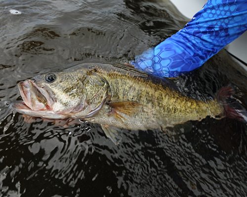
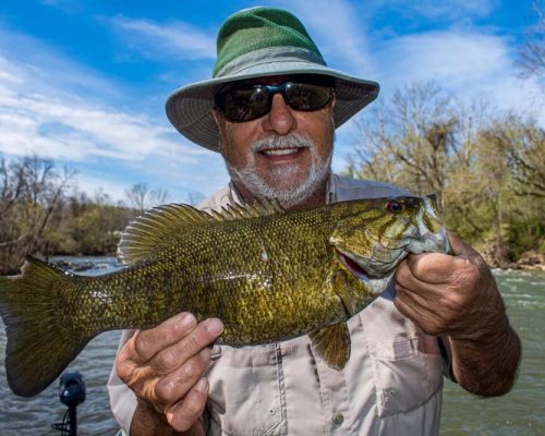
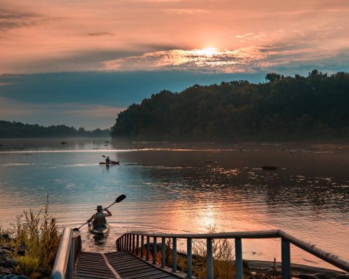
Banister Lake, a small reservoir formed by the Banister River dam located on the East side of Highway 501, has a maximum depth of 30+ feet at the dam.  The old river channel depth ranges from 6 to 13 feet on at mean water levels.  Probably one of the best kept Virginia fishing secrets, Banister offers a plentiful supply of large mouth bass, sunfish, crappie, and catfish.  Five to nine pound large mouth bass aren’t unusual.  Banister River (below the dam) offers the opportunity to fight twelve to fifteen pound stripers in fast-running water during late April to mid May.

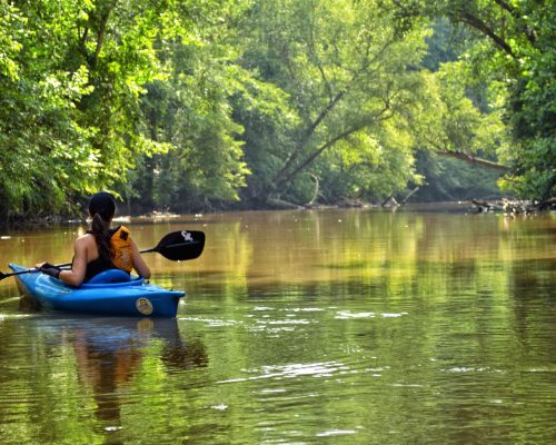
Keep an eye out for wildlife while on the river: beaver, river otter, bald eagles, osprey, great blue herons, and various hawks

BANISTER RIVER ACCESS POINTS | The Banister enters Halifax County from Pittsylvania near Hermosa, and has one public boat landing and four bridge crossings in the county, which make it possible to paddle the following stretches: Mt. Airy to Leda | 10 miles | 4-5 hours Leda to Meadville | 6 miles | 2-3 hours Meadville to Halifax | 10.5 miles | 5 hours Halifax to US 360 | 5 miles | 2-3 hours US 360 to Wolftrap | 3 miles | 1-1.5 hours

Banister Lake is a 400-acre impoundment in Halifax County, Virginia. The lake is a mainstream impoundment of the Banister River and serves as a drinking water supply for the Town of Halifax.

Anglers fishing Banister Lake are likely to catch Largemouth Bass, Channel Catfish, Bluegill, Redear Sunfish (AKA shellcracker), Chain Pickerel, and crappie.

DAN RIVER

The Dan River originates high along the eastern slopes of the Blue Ridge Mountains in Patrick County and flows easterly until it empties into 50,000-acre John H. Kerr Reservoir (Buggs Island Lake) near Clarksville, Virginia. The Dan River is a stream for all seasons and the choice of a variety of anglers. It’s hard to imagine while standing on the banks of John. H. Kerr Reservoir that four counties to the west, the Dan River is a sparkling mountain stream and home to the native brook trout.

DAN RIVER ACCESS POINTS | The Dan River is the major tributary of the Staunton and has two public boat landings in Halifax County and access at one bridge crossing, which divide the river into the following stretches: Milton (NC) to Pace’s | 14 miles | 4 hours Pace’s to South Boston | 15 miles | 5-6 hours South Boston to Staunton River State Park | 13 miles | 4-5 hours The state park maintains two launching ramps which are accessed from Rt. 344. One is located on the north side of the Dan River and the other is located at the confluence with the Roanoke River.

KERR LAKE (BUGGS ISLAND LAKE)

Kerr Lake (known locally as Buggs Island Lake) and Lake Gaston (North Carolina) make up the flat-water portion of the Blueway. The lakes combine for more than 1,200 miles of shoreline, much of which is public and undeveloped on the Virginia side. Boat ramps and access points are plentiful, allowing you to enjoy the lakes for quick trips or longer excursions. Kerr Lake, in particular, is known for its excellent fishing, with a world record 143-pound blue catfish caught in its waters in 2011. For anglers looking for a more unique experience, on the western end of Kerr Lake is the only bridge-mounted nighttime fishing light system in the United States, so you can start earlier and fish later.

LAKE CONNER

Lake Conner is a 100-acre impoundment in Halifax County, Virginia. The lake is owned and managed by the Virginia Department of Game and Inland Fisheries. Located in rural Southside Virginia, Lake Conner offers anglers great fishing opportunities in a picturesque, wooded setting. However, Lake Conner is best known for holding the state record largemouth bass (16 pounds, 4 ounces) since 1985.

Anglers fishing Lake Conner are likely to catch largemouth bass, channel catfish, black crappie, bluegill, redear sunfish, chain pickerel, yellow perch, and bullhead catfish.

ACCESS POINTS | Lake Conner has a single lane concrete boat ramp and a large gravel parking lot. Additionally, there are a lot of opportunities for anglers without a boat to fish the shoreline adjacent to the boat ramp as well as the dam. Several benches are available for shoreline anglers. No port-a-jon facility is available.

River Stories

Looking for more things to do?

Search here for food, shops, and entertainment in Halifax County, VA.

Show More
Reset Filters